

Since the winter storms of 2025-2026, when yet more houses fell into the sea, local people have been asking: 'Is this just climate change, or could dredging be making matters worse?'
 Image by Fran Crowe. Used with permission
It is February 2026 and the calm after the storm, but cold and wet. A Thorpeness resident stands despairingly in what remains of her once beautiful garden, the rest having been eaten away by the sea. The sounds of demolition machinery attacking a neighbouring house are all too evident. Four homes have recently been lost and eight more are condemned, hers included. 'I have nowhere else to live, nowhere to go,' she says in a scared and desolate voice.
Only a few months previously it had been estimated that coastal homes were safe on this cliff top for at least another ten years. Villagers therefore wonder whether such a dramatic miscalculation has resulted purely from unexpected worsening of climate change with increased storm surges, or if there might be some other influence that exacerbates the situation. Could this be offshore dredging?
A profitable businessThe Crown Estate is the body that manages the seabed for up to 12 nautical miles from the coastline around England, Wales and Northern Ireland and is responsible for granting dredging licences, including those off the East Coast. These licences generate income for the Crown Estate. In addition to licence fees, operators pay a royalty for every tonne of sand and gravel dredged. The Crown Estate's overall net revenue profits are returned to the Treasury.
Most of the dredged material off East Anglia is in great demand in the construction industry as represented by the British Marine Aggregate Producers Association (BMAPA). Both the Crown Estate and BMAPA reject suggestions that licensed offshore dredging is contributing to coastal erosion. Dredging can affect sediment movement and the underwater landscape, with potential consequences for the stability of the near shore, beaches and coastal erosion. The more difficult question is whether offshore aggregate dredging is having any such effect on the Suffolk coast.
Coastal dynamicsOff East Anglia, this natural movement is in a mainly southerly direction and is known as 'longshore drift'. It is crucial for supplying sediment to beaches, which in turn helps to support the base of cliffs. Long experience has shown that any interference with this process, for example putting in hard defences, will cause erosion further down the coast.
Within the sea, sandbanks have a protective effect by reducing the power of the waves as they move towards the shore. Some of Suffolk's coastal towns, villages and businesses have relied on two such banks, the Sizewell and Dunwich Banks. Clearly, if these, or indeed any others, were significantly reduced in size the results at the shore could be devastating.
 Licences granted for aggregate dredging. Used with permission
Dredging activity off the East Coast
If we look at the Marine Aggregate Dredging map of 2022 for the Eastern Region we see immediately that a very large area of licences has been granted offshore between Lowestoft and Caister. There are two more areas further south. The annual amount dredged has varied from 23 km2 (2016 and 2020) to as much as 97 km2 (1998). Could it be that the removal of such large quantities of sand and gravel (160 million tonnes during the 25 years to 2022) has either altered the movement of sediment in some way, or allowed the energy of storm waves to increase, or otherwise caused beaches to shrink, thereby affecting the stability of coastal villages?
The Crown Estate and BMAPA insist that their dredging is in deep water and too far offshore to interfere with longshore drift or cause any 'drawdown' from the coast into newly formed troughs. They emphasise that the average alteration of depth is only 0.33 m, yet the height and depth of the peaks and troughs prior to dredging remains unclear.
Evidently, the sand and gravel only come from what they refer to as 'fossil deposits' which they say are mostly immobile. However, they do admit that 'sandbanks represent the nearest point of potential influence from dredging taking place offshore'.
The vulnerability of offshore sandbanks Sizewell nuclear poser stations are worryingly close to the sea. Image used with permission
Local swimmers have been puzzled by how sandbanks that they used to stand on have mysteriously vanished. So, what about the protective Sizewell and Dunwich banks? During the last few decades hydrographic charts have shown consistent erosion of the two with lowering of the crests and a spreading out along the eastern contours. Could dredging be a contributing factor?
Recent events suggest that they are no longer substantial enough to prevent storm surges from ripping away the soft cliffs at Thorpeness. It is also a worry that Sizewell nuclear power stations A and B lie just 4 km to the north, with C currently under construction. The company is already having to consider recharge of the soft defences along the beach.
A trustworthy science?As Alan Brampton, who carried out research for the Crown Estate, has said, he is engaged in 'an inexact science. Sediment transport is very difficult to model.' Distressed coastal residents are therefore left with more questions than answers.
Nevertheless, old-fashioned commonsense indicates that such a very large area of offshore dredging could be having an impact on East Anglia's complex and finely balanced coastal processes. We interfere with these at our peril.
More from East Anglia Bylines
 Climate
"Sorry, you are on your own!" climate crisis hits Norfolk
by Stephen McNair 3 December 2023
 Environment
Coastal erosion has forced vulnerable villages to confront 'hard truths'
by Owen Sennitt, Local Democracy Reporter 5 February 2026
 Anglia
Coastal erosion is unstoppable - so how do we live with it?
by Dr Sophie A Day 20 October 2022
 Truth is power
Nominate an organisation that needs scrutiny
NOMINATEThe post Dredging for profit but losing our villages? first appeared on East Anglia Bylines.

We are all familiar with the fable of the boiling frog: heat the water slowly enough, and it sits peacefully until it is too late. It is a warning about how immediate feedback loops fail when danger creeps up incrementally.
In ecology, this short-term failure compounds into Shifting Baseline Syndrome. Each generation accepts the degraded state of the natural world they inherit as normal. We no longer hear the morning chorus our grandparents grew up with. We reset our expectations with every generation - not just failing to react as the crisis escalates, but forgetting how rich and vibrant our living systems used to be.
An insider's view of local governmentIn political life, an even deeper dynamic is at play. Anthropologist Alexei Yurchak termed it 'hypernormalisation' when describing the final years of the USSR - a concept later brought to prominence by filmmaker Adam Curtis. It describes a system where politicians, civil servants and the public know the status quo is failing and the official narrative is fiction, yet everyone maintains the façade because confronting reality feels too radical for our institutions.
Over my five years as a councillor, and having chaired Norwich City Council's Climate and Ecological Emergency Executive Panel, I have seen first-hand how local government actually functions. I have worked alongside capable, knowledgeable council officers who do brilliant work within the system. But that insider view exposes a fundamental structural flaw: a bureaucratic cup game where cash-strapped councils compete against one another for tiny, short-term grants.
In this setup, even visionary long-term plans are squeezed into short-term political cycles. Officers and councillors alike are kept trapped plugging leaks in the present rather than preparing our communities for the future.
Did you get the memo?Yet I know the wealth of experience local authorities have. And I know far more detailed, national-level intelligence exists behind closed doors in Whitehall that local representatives are barred from seeing. Local government expertise would help frame the county's response if they were included in the conversation.
When central government launched its official Prepare campaign, advising households to stockpile three days' worth of food, water and emergency supplies, it was a rare crack in the façade. While Whitehall tells households to prepare, it refuses to equip local communities or municipal authorities with comparable information. The campaign covers a range of emergencies and does not in itself confirm what Whitehall believes about ecological catastrophe, but the contrast remains.
That is why I proposed Motion 14B - 'Transparency, Ecological Risk and Resilience Planning' - as the very first policy motion brought to Norwich City Council under our Green administration, co-sponsored by Leader Lucy Galvin. Our goal is to pioneer a democratic approach to governance, going directly into neighbourhoods to talk openly about climate adaptation and co-designing local resilience with residents. But genuine democracy requires honest information. That is why we formally requested access to the Joint Intelligence Committee's full assessment on ecological collapse.
Neither confirm nor denyDefra's official response - hiding behind the "neither confirm nor deny" formula historically associated with nuclear secrecy - fuels the suspicion that the state is withholding the full assessment because confronting its findings would demand a total shift in how we govern.
The House of Commons Environmental Audit Committee also sought access to the full assessment, including on a confidential basis, but was refused. In a letter dated 17 June, its chair asked the minister either to provide the assessment or publicly explain why access was being denied.
This secrecy is dangerous. Climate risk specialists at the Tyndall Centre for Climate Change Research, based here in Norwich, have repeatedly shown that effective adaptation depends in part on effective risk communication and public trust. Suppressing ecological intelligence does not prevent panic; it creates an information vacuum where fear, rumour and conspiracy flourish.
The political consequences of a vacuumCurrent political discourse fixates on border control and migration, treating human movement as an isolated political threat. But treating migration as the root problem ignores one of the major forces likely to shape human movement in coming decades: severe ecological breakdown.
The government's own publicly released nature security assessment makes this plain. Using intelligence frameworks, Defra warns that global ecosystem collapse poses a direct threat to UK national security. With the UK importing 40% of its food, domestic security relies on critical ecosystems thousands of miles away, where cascading environmental failure makes severe crop losses, water insecurity, and intense resource competition highly likely. Without major intervention, the state's own assessment warns that some critical ecosystems face a realistic possibility of beginning to collapse from 2030, with potentially severe consequences for food production.
By narrowing public discourse to border walls and administrative tweaks, Whitehall allows reactionary politics to weaponise symptoms while ignoring causes. Protecting the living world is not a soft preference or a matter of "being nice to nature"; ecological stability underpins our national food grid, public health, and basic economic survival.
The country needs an honest discussionOur current state strategy is fundamentally incoherent. Whitehall cuts international aid while boosting military expenditure, treating security as something delivered purely through defence contracts and border policing - all while the primary driver of global instability sits unaddressed. Pledges to plant trees or deliver minor carbon offsets fail to grasp the magnitude of the moment. We need a complete paradigm shift.
Civilisation only exists because of remarkably stable climate conditions over the last ten thousand years. Human survival has always hinged on our capacity to adapt - to face reality directly and organise ourselves accordingly.
When I wrote the motion, I knew Whitehall was unlikely to hand over classified intelligence. Demanding access was a deliberate act to expose institutional secrecy and start an honest discussion about our collective future.
At this year's Green Party conference, Adrian Ramsay MP proposed No National Security Without Nature Security. The motion formally asserts a fundamental truth: true national defence cannot be found in military posturing or state secrecy while the ecological foundations of our survival break down beneath us. Real security requires a state that trusts its own people with the truth, treating living systems as critical infrastructure, so that local council chambers and empowered citizens can proactively adapt to the world as it actually is.
More from East Anglia Bylines
 Climate
New emergency briefing warns UK climate risks are accelerating
by Mark Popay 29 April 2026
 Climate
For food security our diets must change
by Jenny Canham 10 September 2026
 Community
Our new climate: adapting to survive - and thrive
by Prof Rupert Read 21 February 2026
Truth is power
Nominate an organisation that needs scrutiny
NOMINATEThe post Are we being told enough about the ecological collapse? first appeared on East Anglia Bylines.

Over the last weekend many of the 5,000 volunteers who carry out a monthly count of waterbirds for the British Trust for Ornithology (BTO) headed for their local reservoirs.
For the small team that count at Hanningfield Reservoir in Essex, there were mixed feelings. Water levels had been dropping steadily over the months of drought, relieved by little or no appreciable rainfall.
 Low water levels at Hanningfield Reservoir in Essex. Image author-provided.
But 2026 has been exceptional, with regulars recalling the severe drought of 1976. And as the birders prepared for the Wetland Bird Survey (WeBS), the BTO itself warned of the impact of low water levels on reservoir birds.
"Reservoirs can be particularly important for wintering wildfowl, providing feeding and roosting habitat when natural wetlands are unavailable or unsuitable. Changes in water levels can, however, alter the availability of shallow margins and feeding areas, potentially affecting where birds congregate."
Hanningfield has been attracting waterbirds since it was filled in 1954. It is the 11th largest reservoir in England with a capacity of 25,500 million litres. Unlike many reservoirs it is set in rolling countryside with wooded margins and shallow lagoons holding reedbeds, enhancing its attractiveness to birds of many species.
But it is its appeal to water birds that has led to its status as a Site of Special Scientific Interest.
Falling numbersTwo species to be found at Hanningfield, often in large numbers, are Tufted Duck and Coot. In October 2023, the WeBS survey recorded 1,227 Tufted Duck and 2,474 Coot; the following year there were a more modest 203 Tufted Duck and 1,104 Coot.
In October last year, when Essex and the rest of the East of England was experiencing an exceptionally prolonged dry period, the number of Tufted Duck fell to just 25, and Coot to 176.
While numbers climbed slowly as the reservoir filled during the wet winter of 2025/26, the recovery stalled as a dry spring turned into a hot, dry summer. Water levels fell dramatically through evaporation and usage. By September Tufted Duck numbered 56 and Coot only 28.
So, with a further month of barely detectable rainfall, it was unsurprising to find numbers at an all-time low - in single figures with eight Tufted Duck and a mere six Coot.
Where have the birds gone?Two questions arise. Why have they left, and where have they gone?
Coot prefer shallow vegetated lakes, where they dabble for plant material and small crustacea and molluscs. The retreat of the water has exposed the shallow reservoir floor where the food on which they depend was to be found, the sun baking the exposed mud to a harsh, hostile environment.
 Nesting coot at Hanningfield. Image by Sarah White.
Tufted Ducks, in contrast, dive for their preferred molluscs. Quite why the retreat of the water to the reservoir's deeper core should affect them so dramatically is not as clear, but may be related to the increased competition in a limited area and less stressed feeding opportunities elsewhere.
Where they and the Coot have gone to is unclear. Other reservoirs and natural waters in the South East report a similar story, and analysis of the WeBS data may provide answers.
But the prospects for the rest of the year and particularly for 2027 are extremely worrying. Will Hanningfield get its waterbirds back?
More from East Anglia Bylines
 Climate
A warning written in ash - a threat to our world
by Leslie Cater 18 August 2026
 Environment
Nature reserve brings new hope for declining sand martins
by Rebecca Turner 16 August 2026
 Environment
What we've lost at Dunwich Heath
by David Jobbins 31 July 2026

What happens when the media itself becomes part of the problem? Who holds it to account? 14 years after the Leveson Inquiry reported its findings, has anything really changed? And how can we build something better?
Join Bylines Network on Wednesday 21 October, for a vital conversation about the media Britain needs — and what it will take to get there.
The event will conclude with a live audience Q&A.
BOOK NOWThe post Where have Hanningfield's waterbirds gone? first appeared on East Anglia Bylines.

A new three-year programme will enable pupils across the East of England to investigate the climate challenges facing their own schools and help shape the response.
I once visited a school where everyone knew one corner of the site flooded after heavy rain. Pupils knew it. Staff knew it. Site teams knew to keep an eye on it. What nobody really knew was why.
Had a drain become blocked? Was water arriving from somewhere else on the site? Had changes over time altered where rainfall collected? A familiar problem, but the evidence probably wasn't there.
Many school climate conversations begin in a similar place. The issue might be an overheated classroom, poor air quality at the school gate, wasted energy or the absence of wildlife from the school grounds. Schools know something is happening. They often care deeply about it. The challenge is finding the time, support and evidence needed to understand it properly.
ClimateReady Schools begins there.
The Royal Society has awarded the University of East Anglia (UEA) and the Tyndall Centre for Climate Change Research a £105,000 Science Community Grant to work with 25 schools across the East of England over the next three years. The programme will support pupils in carrying out scientific investigations into their own school environments and sharing what they discover with the people responsible for making decisions about those places.
 Climate Ready Schools co-leads Kit Marie Rackley (L) and Abby Onencan (R) outside The Royal Society building on Tuesday 6th October for the Science Community Grant Launch Meeting. Image credit: Debbie Rowe, used with permission
Starting with the places pupils know
Schools will investigate issues including energy, air quality, biodiversity, flooding, food and waste, and climate resilience. What's important is that these investigations begin with places pupils already know.
One school may investigate where heat is escaping from a building. Another might compare air quality around the school entrance at different times of day. Elsewhere, pupils could sort and measure lunchtime waste, looking at what is being left behind and whether changes to menus, portions or recycling arrangements make a difference.
Pupils will develop questions, gather evidence and present recommendations to school leaders. These findings could also support schools' own energy-saving, behaviour-change and Climate Action Plan priorities, giving leaders and governors evidence drawn from their site rather than a generic checklist.
Anyone who has worked with young people on genuine investigations will recognise what happens next. Assumptions turn out to be wrong. Results raise new questions. Sometimes a problem turns out to be more complicated than it first appeared. That's good science.
Beyond the one-off school visitEach participating school will work with a named Climate Ambassador whose expertise connects to the investigations taking place. Ambassadors will come from research, science and related STEM fields, with schools and volunteers matched according to the needs of the project and the experience they can bring.
What appeals to me about the programme is that these relationships will develop over three years rather than through a single assembly or careers talk.
Schools will get to know the Ambassador. The Ambassador will get to know the school.
Pupils will revisit ideas, build confidence and develop familiarity with scientific thinking over time. Teachers will receive support before each module and become part of a wider regional network sharing experiences and resources.
Some of the best questions I heard during 13 years teaching geography were ones I had never considered until a pupil asked them. The programme recognises that learning can flow in both directions.
Looking again at the East of EnglandPeople who don't know our region particularly well might sometimes imagine a largely prosperous region of market towns, commuter settlements and countryside. Spend time working with schools, though, and a more complicated geography emerges.
There are coastal communities living with erosion and flooding. Rural schools where universities can feel physically distant. Places where young people may rarely meet working scientists despite living alongside some of the country's most visible climate-related risks.
ClimateReady Schools aims to widen participation by creating sustained opportunities for young people who have historically been underrepresented in higher education and STEM. Rather than lowering expectations, this means giving more pupils the time, tools and relationships needed to take part in serious scientific enquiry.
Everyday school life can look different once pupils begin gathering evidence. A travel survey can reveal how distance, safety and public transport shape the way people reach school. Recording first flowering, leaf fall or the arrival of migratory birds can reveal seasonal changes that might otherwise pass unnoticed. Repeating an investigation can show whether a school intervention changed habits or simply produced a short-lived response.
The science remains rigorous, and there is no need to invent relevance.
Building something that lastsThe equipment provided through the programme will remain with schools, allowing future year groups to continue and expand investigations. Schools will also have opportunities to share findings through regional showcases and networks linked to the UEA Tyndall Centre's Schools Climate Hub.
ClimateReady Schools will not solve every challenge facing schools. What it can do is create more room for curiosity, investigation and evidence-informed decision-making.
In many cases, the starting point will be surprisingly ordinary. A puddle that always forms in the same place. A classroom that is always warmer than the others. A patch of grass that becomes more interesting once somebody starts looking closely at what lives there.
For 25 schools across the East of England, climate action will begin with questions like these and with the time and support to investigate them properly.
That feels like a good place to start.
More from East Anglia Bylines
 Education
When 'banter' becomes bullying: new safeguarding guidance for schools
by Mary-Jo Hill 8 October 2026
 Climate
New school safeguarding guidance has a climate blind spot
by Kit Marie Rackley 17 July 2026
 Activism
Suffolk MP backs radical plan to end sexual harassment in schools
by Jenny Rhodes 8 March 2026
 Friends of Bylines Network
There has never been a greater need for grassroots journalism that investigates the stories that really matter, holds power to account and champions the voices of everyday citizens. We are proudly powered by volunteers but what we do isn't free.
STAND WITH US for independent, citizen-led journalism that makes democracy stronger, and you will even get some exclusive benefits.
BECOME A FRIENDThe post 'ClimateReady Schools': putting young people at the heart of climate action first appeared on East Anglia Bylines.

Dear Editor,
I am constantly surprised how little consideration is given to agrivoltaics - an option where solar panels are raised enough to allow crops to be grown underneath. This has been proven beneficial for many crops in our new climate conditions. Canada has embraced this, and I understand that Egypt is now doing the same.
East Anglia suffers from insufficient rain and reducing ground water. Anything that mitigates the need to irrigate crops must surely be worth some careful consideration?
I also note that the government decided not to pursue the French requirement to place solar panels over car parks…
Sarah Mould
New Costessey
More from East Anglia Bylines
 Climate
As Britain bakes, ministers quietly park plans for solar carports
by Anna Damski 26 June 2026
 Business
Heatwaves, farmland and solar energy
by East Anglia Bylines 7 July 2026
 Anglia
New research: birdlife soars on nature-friendly solar farms
by Paul Casciato 17 February 2025
Friends of Bylines Network
There has never been a greater need for grassroots journalism that investigates the stories that really matter, holds power to account and champions the voices of everyday citizens. We are proudly powered by volunteers but what we do isn't free.
STAND WITH US for independent, citizen-led journalism that makes democracy stronger, and you will even get some exclusive benefits.
BECOME A FRIENDThe post Letter: Why aren't we considering agrivoltaics? first appeared on East Anglia Bylines.

By Katie Jenkins, University of East Anglia and Robert James Nicholls, University of East Anglia
Stretching across much of eastern England, the Fens produce a third of the country's vegetables and support tens of thousands of jobs. Yet around 33% of the region lies below average sea level, while 87% is below the highest spring tides
The landscape only exists due to centuries of engineering - pumps, embankments and drainage channels - that keeps water moving almost constantly. Now climate change is introducing new challenges that this system was never designed to face.
The Fens face several climate threats that reinforce one another. Rising sea levels, heavier downpours, hotter summers, longer droughts and biodiversity loss are all expected to intensify over the coming decades. These are all serious challenges, and in the Fens they will play out within one tightly interconnected system.
The Fens cover parts of Cambridgeshire, Lincolnshire and Norfolk:
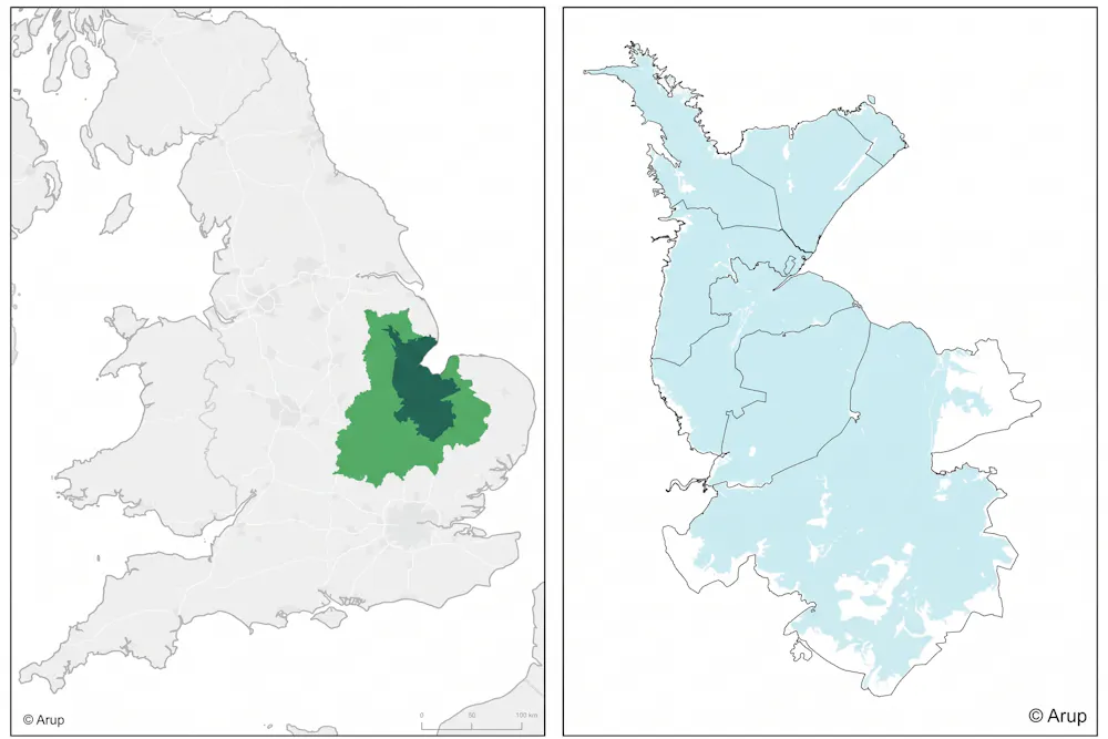 The Fens (dark green) and their wider catchment area (light green). The map on the right shows the area (shaded blue) below the mean high spring tides that would be at risk without human engineering. Environment Agency / Arup: 'Fens 2100+: Summary baseline report', CC BY-SA
In June, we published an academic analysis of these climate risks in the Fens. Our research examined flood risk from rivers, surface water and the sea, alongside drought, water scarcity, heat, biodiversity loss and agricultural productivity. It found that these hazards increasingly overlap as the climate warms.
With around 2°C of warming, the region will experience more frequent flooding, more extreme heat, declining summer river flows and accelerated biodiversity loss.
By 2100, under a 4°C warming scenario, annual flood damages to homes and businesses in the region could rise from £16 million today to £250 million, while ecosystems could collapse and parts of the Fens would be rendered uninhabitable without major investment in new infrastructure.
Importantly, sea-level rise is different from other risks as it will continue for centuries even if global temperatures are stabilised. Even a high emissions scenario, where the sea would rise by a metre by 2100, would still be followed by further rise. This is an existential risk for the low-lying Fens, meaning that more radical adaptation approaches will be needed in the long term. Decisions about how to adapt must begin well before then, as major changes to infrastructure and land management take decades to plan and implement.
Connected climate hazards Fens in the evening image by Kate Jewell. CC BY-SA 2.0
National climate risk assessments are essential, but they can mask the severity and complexity facing regions with distinct characteristics. The Fens is a case in point given its low-lying geography means that it is exposed to multiple climate risks that can compound each other.
River flows could fall by more than 25% under 4°C warming, at the same time as floods from surface water, rivers and seas would increase. Agriculture could faces crop losses from both drought and water scarcity and from water logging and flooding, alongside a decline in insect pollinators that could reduce productivity. These issues cannot be managed by only tackling single hazards in turn.
We therefore developed a way to assess all the climate-related risks to a single place, rather than looking at each hazard in isolation. This provides an integrated picture of how multiple risks develop and interact over time, and gives interested people and groups locally relevant information to help them plan for climate change.
 A schematic map of the many rivers, canals and other waterways that keep the Fens drained. Environment Agency / Arup: 'Fens 2100+: Summary baseline report', CC BY-SA
Aligned with the engineering evidence
The Environment Agency's Fens 2100+ programme, published in April 2026, reaches similar conclusions on the region's infrastructure. For the first time, it brings together evidence on the entire flood risk management system, covering around 17,000 assets including 318 pumping stations, embankments and tidal defences.
Together, these assets are estimated to provide £58.8 billion in benefits through avoided flood damage over the next 100 years. However, nearly a third of these defences need upgrading in the next 15 years.
Both our analysis and the Fens 2100+ evidence conclude that dealing with these challenges separately or only in the short term cannot work.
The Fens needs to be considered as one connected landscape with decisions about flood protection, water, agriculture and the environment made together. Coastal lowlands around the world, from the Netherlands to the Mekong delta in Vietnam, are grappling with similar interconnected challenges of sea level rise, flooding and competing demands for land and water. The approach we have developed could be applied to help people in these regions assess their options for adaptation.
Katie Jenkins, British Academy Innovation Fellow, Tyndall Centre for Climate Change Research, and
Robert James Nicholls, Professor of Climate Adaptation, both at University of East Anglia

This article is republished from The Conversation under a Creative Commons license. Read the original article.
 Climate
Is no one concerned about the climate any longer?
by Max Terzza 15 July 2026
Community
Our new climate: adapting to survive - and thrive
by Prof Rupert Read 21 February 2026
 Climate
 change: an expensive myth or a question of survival?
by Marc Ainge 21 November 2025
The post Britain's most artificial landscape may not survive climate change first appeared on East Anglia Bylines.
 Article by Bobby Bascomb
Cities can become dangerously hot during extreme heat events, making it increasingly important for urban planners to find ways to reduce temperatures and protect people from heat exposure. Woodlands, grasslands, lakes and rivers can create significantly cooler microclimates, offering one potential way to reduce urban heat, a new study finds.
The study focused on Guildford, a town in southeast England with a variety of green-blue infrastructure (GBI) types. GBI are land and water-based features integrated with each other and the built environment to provide mutually beneficial services, including wildlife corridors, flood mitigation and cooling.
In Guildford, researchers collected data from six sites — a woodland, grassland, lakeside, vegetated green wall, small pocket park and riverside — and compared how effective they are in cooling the areas around them. They compared each site with a built-up location.
The team established sensors at each site and recorded temperatures at one-minute intervals, from June 2023 till the end of August 2025. These sensors recorded temperatures through both normal climatic conditions and several extreme heat events. The researchers also used satellite data over the same timeline to get a more robust picture of the conditions in each location.
The team found that all six GBI sites were cooler by 1.8-2.5° Celsius than their built-up comparison site. The cooling was more pronounced during extreme heat events. The woodland site was upward of 6°C cooler than the built environment on the hottest days. The riverside and pocket park were cooler by 3.5°C (on the hottest days. Overall, the green wall had the least cooling effect, while the woodland had the most.

 Bury St Edmunds image by John Fielding. via Wikimedia Commons (CC BY 2.0) | Park Town, Oxford image by Jpbowen. via Wikimedia Commons (CC BY-SA 3.0)
"Those nuances are important because they reinforce something we increasingly see in urban heat research: there isn't a single number we can attach to a tree, park, lake, or green wall and say, 'this is how much cooling it provides,'" Vivek Shandas, professor of geography with Portland State University, U.S., who was not part of the study, told Mongabay by email. "Cooling depends on the design of the place, its scale, the surrounding buildings and pavement, weather conditions, and time of day."
 Willen Lake, Milton Keynes image © John Fielding. Used with permission
The researchers acknowledge that their observations are from just one site for every GBI type, and local conditions could play a significant role in their findings.
Still, Shandas said the study moves the research beyond the simple notion that "green is good" and "toward a much more actionable question: How do we design cities so that cooling is available where and when people actually need it?" The United Nations recently announced that global temperatures will soon surpass the climate change target established by the 2015 Paris Agreement, underscoring the urgent need for cities to adapt to extreme heat.
This article is republished from Mongabay under a Creative Commons license. Read the original article.
More from East Anglia Bylines
 Climate
Shade, cooling and survival: why we need more trees
by Kate Moore 11 July 2026
 Climate
Startling Climate Change Heatmaps Reveal Future UK Peril
by Prof Chris Brierley 4 July 2024
 Climate
Red alert in East Anglia - how to deal with 40°C heat
by East Anglia Bylines 17 July 2022
Truth is power
Nominate an organisation that needs scrutiny
NOMINATEThe post What green options are best for urban cooling? first appeared on East Anglia Bylines.

This summer has been a rude awakening for many of us. For a long time, the consequences of climate change could feel far away, both in time and location. But record-breaking heat, drought and parched landscapes are making the reality of a changing climate increasingly difficult to ignore.
The science tells us that our own activity as a species is driving climate change. The United Nations confirms that climate change is caused by human activity, particularly the burning of fossil fuels, which increases greenhouse gases such as carbon dioxide in the atmosphere.
But climate change isn't only changing the weather around us. It's also putting pressure on the systems we rely on to produce our food. Drought, rising temperatures and changing rainfall patterns can affect crops, animals and water supplies, while agriculture itself places significant demands on land and freshwater.
So how can we make sure we have enough food to feed the current population of 8.3 billion people on the planet, both now and in the future?
How efficient is our food system? Image by Fotokostic. Licensed by Shutterstock
Food production as a whole is responsible for around one third of global greenhouse gas emissions, according to the United Nations.
When we grow crops to feed animals, we are effectively producing food twice - first growing plants and using them to feed animals to produce meat, milk or eggs. Animals use much of the energy and nutrients in their feed simply to live, rather than converting it into food that humans can eat.
The Organisation for Economic Co-operation and Development (OECD) estimates that only around 23% of the energy in animal feed is ultimately converted into human food, with the remainder used largely to maintain the animal's body. This creates competition for crops, land and water that could otherwise be used directly to feed people. The problem will become more significant as the climate warms: rising temperatures, drought and changing rainfall already affect crop yields and animal health.
Carbon emissionsAnimal agriculture contributes to global warming through several different greenhouse gases:
- Cows and sheep produce methane through digestion
- Manure and fertilisers used to grow animal feed release nitrous oxide
- Carbon dioxide is also released through fossil-fuel use, and when forests and other ecosystems are cleared for livestock grazing or growing animal feed
Together, these emissions trap heat in the atmosphere and contribute to rising global temperatures. These statistics by Our World in Data, show that many of the biggest producers of greenhouse gases come from industries that farm animals.

Research shows that, when comparing foods by the amount of protein they provide, beef has an average footprint of around almost 50kg of greenhouse gas emissions per 100g of protein, while lamb is around 20kg. By comparison, grains are around 2.7kg, groundnuts about 1.23kg and peas around 0.44kg.
Animal agriculture also contributes to other environmental pressures, including biodiversity loss, soil degradation and pollution.
The water footprint of our foodAnimals require water to drink, but a large proportion of the water footprint of animal products comes from growing the food they eat.
Research by Cranfield University shows that the water footprint of producing British beef have been assessed at more than 15,000 litres for each kilogram. In comparison, vegetable foods need much less water. For example, 1kg of potatoes uses 287 litres of water.
Land and proteinLand use tells a similar story. Producing meat requires land to raise animals and, in many farming systems, land to grow their feed. Producing food directly from plants can therefore be considerably more land-efficient.
Research analysed by Our World in Data compares land area needed for protein produced by different foodstuffs. It found that beef and lamb require vastly more land to produce protein than plant-based sources such as peas and tofu.

This matters for food security. As populations grow and climate change puts additional pressure on agricultural systems, making efficient use of available land becomes increasingly important.
According to Our World in Data, less than half of the world's cereals are eaten directly by humans: 41% is used for animal feed and 11% for biofuels. It concludes that if people moved towards a plant-based diet, global agricultural land use could be dramatically reduced, cutting out beef having the largest impact of all.
Our daily choices matterThe drought may be a threat to farming and food supply, but actually farming is a threat to our water supply (and more). Milk gets mentioned here as a product at risk - but it takes 1,000 litres of tap water to make 1 litre of cow milk. Oat milk by contrast takes just 50 litres… pic.twitter.com/YAgme5cVJC
— Dale Vince (@DaleVince) August 11, 2026
Climate change can sometimes feel like a problem too large for individuals to influence.
While we need urgent action from companies and governments to ensure that climate change goals are set and met, diet is one way we can help to make an impact in our own lives.
The drought this summer is a reminder that our planet's resources are not limitless. The choices we make about what we put on our plates can be part of creating a food system that uses land and water more efficiently, reduces emissions and is better prepared for the challenges ahead.
Scientists, environmentalists and conservationists have been warning for decades about environmental destruction. One of the most familiar voices is Sir David Attenborough, who celebrated his 100th birthday this year.
In recent years, Attenborough has increasingly focused on the relationship between human activity, the natural world and climate change. His documentaries have brought the scale of the environmental crisis into millions of homes, while highlighting some of the changes we can make to reduce our impact.
One change he advocates is eating less meat and more plant-based food.
Attenborough has said: "We must change our diet. The planet can't support billions of meat-eaters. If we had a mostly plant-based diet we could increase the yield of the land."
Where do we start?At The Vegetarian Society, we advocate for starting with small switches that can add up to create a real impact. By beginning to eat more plants and less meat, we can help to reduce carbon, prevent emissions and save water - playing our part to ensure stronger food security for the future.
 Environment
How new smarter greenhouses could improve the UK's food security
by Dr Sven Batke 12 February 2025
 Climate
Alarm bells - Britain's food system is vulnerable
by Kate Moore 24 May 2026
 Community
 gardens: solving the problem of food security
by Prof Neli Demireva 22 February 2026
The post For food security our diets must change first appeared on East Anglia Bylines.

Now the summer holidays have drawn to a close after weeks of exceptional heat and destructive wildfires, prominent voices continue to blame adults and education for children's climate concerns. But young people are also responding to what they can see, smell and experience for themselves.
August is behind us, and East Anglia has finally had some space to breathe.
The most oppressive heat has receded, and some rain and cooler spells have brought welcome relief to gardens, fields and exhausted communities, even if the effects of prolonged heat and dry weather cannot be undone by a few showers.
At Dunwich Heath, the fire incident formally ended on 21 August. Yet the reserve and adjoining beach remained closed while the National Trust assessed a landscape transformed by fire, where familiar paths and landmarks had disappeared and damaged trees could still collapse.
The immediate emergency may have passed, but the consequences haven't. With the end of the summer holidays, we should remember what children have lived through. The heat, smoke and warnings don't disappear from their experience simply because a new school year begins.
When concern becomes a culture-war targetA recent Telegraph article asked how parents were supposedly failing to protect children from "climate hysteria". Its subheading placed schools and social media in the foreground as drivers of young people's fears.
"Mummy, when will we all go extinct?" is not a question which any parent wants to hear, especially right before bedtime.
But for Laura*, 47, a marketing executive in Surrey, that was just the beginning of her 12-year-old daughter Anna's* anxiety about climate change

From soay sheep to British white cattle, iron age pigs and water buffalo, grazing animals are helping Wildlife Trusts maintain a rich variety of habitats for flora and fauna at their nature reserves.
Livestock help create the conditions needed by many plants, insects, mammals, birds and amphibians to thrive. In summer, when many wildflowers and grasses have flowered and set seed, animal munching is particularly important. In areas like the Norfolk Brecks, the hot dry conditions stem the growth of vigorous grass species, allowing delicate plants to grow. The lack of fresh growth means grazing animals remove more of the older 'thatch' that can build up, smothering rare plants. In Hertfordshire, at Fir & Pond Woods, such action has resulted in the establishment of the critically endangered scarce tufted-sedge.
But prolonged heatwave conditions bring challenges in how livestock is managed.
Thirsty cattle, muddy pigs I

 Iron age pigs wallowing. Credit Wildlife Trust BCN / A herd of red poll calves on very dry grassland. Credit Essex Wildlife Trust. / British white cattle. Credit Nick Acheson, Norfolk Wildlife Trust. Used with permission.
The hot, dry weather means greater wildfire risk and less grazing available. So livestock must be moved more frequently. This requires more planning and equipment to distribute essential water across the Trust's reserves.
At Aldbury Nowers, near Tring, Herts and Middlesex Wildlife Trust have adapted a trailer to become a 500 litre water bowser facilitating easier refill of existing, smaller water containers. Norfolk Wildlife Trust have had to bring in 8000 litres of water to maintain the health of their lactating, and therefore thirsty, British white cattle at Thompson Common.
Highland cows need water to cool off. They can often be seen standing in the lake at Summer Leys Nature Reserve. But in their quest for water, cattle will venture further into ponds and ditches, which have the potential to run dry, and they can get stuck. "This year we have had two such incidents," Jonathan Preston, nature conservation manager at Norfolk Wildlife Trust told East Anglia Bylines. "Happily on both occasions the [British white] cow was pulled out without harm."
Unlike cows and sheep, pigs don't sweat. They use mud as a natural sunscreen. So Wildlife Trust BCN have created a muddy wallow for their iron age pigs, kept to crop the invasive New Zealand pygmy weed. The pigs enter their mud bath, cover themselves and then lie in the shade.
Essex Wildlife Trust is facing the problem of a dry water channel on Blue House Farm nature reserve in North Fambridge. A priority is bringing water back into the environment, through wetland restoration and the creation of more ponds.
A lifeline for graziers
 Soay ewes and lambs at Aldbury Nowers. Credit Herts and Middlesex Wildlife Trust / Water Buffalo at Thorley Wash. Credit Robert Phillips. Used with permission
Reserves with wet grassland habitats are more resilient in heatwave conditions. This enables the Trusts to support local farmers whose land is affected by drought and whose livestock would be reliant on silage, normally reserved for winter.
"Some [reserves] are still much lusher than the grasslands available on farms," said Anna Daniels, senior reserves officer, Herts and Middlesex Wildlife Trust. "So our reserves are providing an important grazing resource at a time when graziers are facing a shortage of grass."
The Trust has found that graziers are more willing to tackle the challenging logistics of moving animals on to less accessible areas of their reserves. "It's a great example of a win, win situation - our reserves at Danemead, and Rye Meads, both near Hoddesdon, and King's Meads in Ware are all benefiting from more conservation grazing than they otherwise would, and the cattle there are enjoying a good feed!"
Nature's workforce on four legsLivestock are vital to managing nature reserves. Around 25% of Essex Wildlife Trust reserves rely on grazing. "They are doing work that would otherwise require an enormous amount of manual grassland and scrub management by people, while creating the small-scale variations in habitat that so many species depend on," Daniels explains.

 Dark Green Fritillary butterflies / Chalkhill Blue butterfly. Credit Iain Ward. Used with permission
As well as red poll and dexter cattle, Herts and Middlesex Wildlife Trust use soay sheep. This hardy, primitive Hebridean breed thrives on sparse and tough vegetation that other breeds may avoid. The action of grazing the scrub and lower-nutrient chalk grassland benefits the cowslip, common rock-rose, marjoram and carline thistle which feed butterflies, including dark green fritillary and chalkhill blue.
At Thorley Wash reserve, near Bishops Stortford, an unusual sight may be seen - a herd of water buffalo grazing the rare fen. The action of these animals in ditches and marshy areas improves biodiversity, especially helping the endangered water vole.
"But conservation grazing is never simply a case of putting animals on a reserve and leaving them there," says Daniels. "We need to understand the animals, the vegetation, the weather and the needs of the site, and constantly adapt. This heatwave has certainly given us plenty to think about, but it has also shown just how valuable our wetlands and wet grassland nature reserves can be when conditions are difficult elsewhere."
Indeed the heatwave and drought conditions have highlighted the importance of the work of the Wildlife Trusts, their support to farmers and the complexity of conservation grazing in the face of a changing climate. Do support them.
The Wildlife Trusts are local conservation charities working to protect wildlife and help people connect with nature. They rely on volunteers and donations to care for wild places on your doorstep so that nature can thrive. For more information about the work and reserves in your area or to become a supporter, go to the respective website: Wildlife Beds Cambs Northants, Essex Wildlife Trust, Herts and Middlesex Wildlife Trust, Norfolk Wildlife Trust, Suffolk Wildlife Trust.
More from East Anglia Bylines
 Environment
Norfolk conservationists honoured as nature faces a difficult summer
by East Anglia Bylines 19 August 2026
 Environment
The bird with the most beautiful song returns for the summer
by East Anglia Bylines 14 April 2026
Environment
Nature reserve brings new hope for declining sand martins
by Rebecca Turner 16 August 2026
 Download the Bylines app to get our content straight to your phone!
Get the app
The post Wildlife trusts, grazing animals and the challenge of drought first appeared on East Anglia Bylines.


